Comprehensive Energy Data Intelligence
Information About Energy Companies, Their Assets, Market Deals, Industry Documents and More...
Rextag: first 2019 GIS Data Update
02/06/2019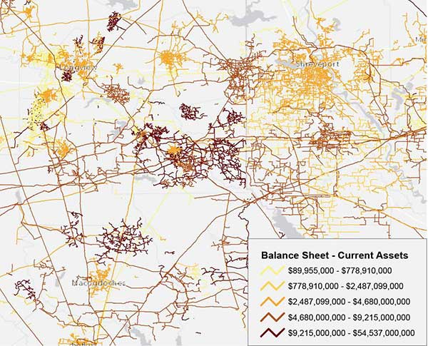
As promised, the latest Rextag GIS Data Update has been released. Here are some of the highlights and some examples of what you will find in the overhauled first update of 2019.
High Addition of Digitized Miles of Pipelines:
- Our team has added more than 33,000 miles of digitized pipelines to this update, possibly the largest update in pipeline mileage in many years.
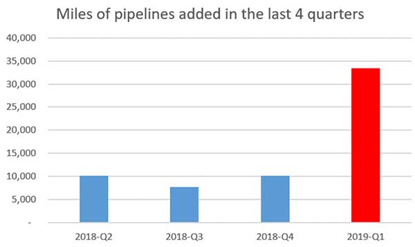
- On top of this major mileage addition, more pipeline mileage is scheduled to be digitized and to be included in the next updates.
Improved Pipeline Diameter Attribution:
- Our team added new diameter values to more than 25,000 miles of pipelines, with more expected to be added over the next year of updates!
Improved Facilities:
- In addition to changes and updates to the current attributes, we have added information on numerous facilities (Terminals, Processing Plants, etc.) and we have changed and improved the data attributes and values to the existing records.
- Furthermore, we are planning to make updates to our facilities data layers a major focus of our GIS Data Update process in 2019.
New Financial Tables:
- To our clients in the finance industry, you would be glad to know that our team has added financial reports on publicly traded companies in the U.S.—along with information on their stock symbols and marketplace.
- The financial tables will be maintained and updated on the same schedule as our GIS data and they will contain information obtained from companies’ public filings.
- An example of potential use of this data: to visualize pipeline owner’s asset values as reported on a company’s balance sheet.
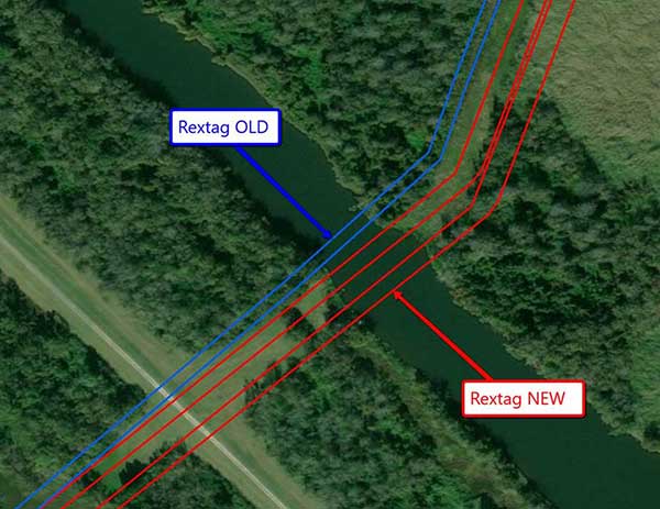
Improved Data Quality:
- We have improved the spatial accuracy of tens of thousands of digitized pipeline miles!
- Further spatial improvements are planned over the next few months.
Expansion of Attributes:
- We have expanded the number of data attributes to house more information we consider of significant value to our data users.
- Some of the attributes may appear “empty” at first, but fear not! We will be filling it the blanks in future updates.
Please feel free to reach out to our team with any questions or concerns on our Contact page
If you are looking for more information about energy companies, their assets, and energy deals, please, contact our sales office mapping@hartenergy.com, Tel. 619-349-4970 or SCHEDULE A DEMO to learn how Rextag can help you leverage energy data for your business.
Geodata Requirements for Solar Farm Siting: TOP US States for Solar Energy
![$data['article']['post_image_alt']](https://images2.rextag.com/public/blog/302_Blog_Geodata Requirements for Solar Farm Siting TOP US States for Solar Energy (2).jpg)
Solar energy is quickly becoming one of the most popular and sustainable ways to generate power. As more people and businesses turn to renewable energy, finding the best spots in the United States to build solar farms is crucial. This is where Geographic Information Systems (GIS) comes in. GIS technology helps us analyze the environment, land features, and land use to identify the best places for solar energy projects. By using GIS, we can boost energy production and reduce the environmental impact, all while helping the country meet its renewable energy goals.
Selected News from GIS Community
![$data['article']['post_image_alt']](https://rextag.com/images/public/blog/Selected-News-from-GIS-Community.jpg)
We think these GIS-related news will be important for the industry in the near future
![$data['article']['post_image_alt']](https://images2.rextag.com/public/blog/328_Blog_Why Are Oil Giants Backing Away from Green Energy Exxon Mobil, BP, Shell and more .jpg)
As world leaders gather at the COP29 climate summit, a surprising trend is emerging: some of the biggest oil companies are scaling back their renewable energy efforts. Why? The answer is simple—profits. Fossil fuels deliver higher returns than renewables, reshaping priorities across the energy industry.
![$data['article']['post_image_alt']](https://images2.rextag.com/public/blog/327_Blog_Oil Market Outlook A Year of Growth but Slower Than Before.jpg)
The global oil market is full of potential but also fraught with challenges. Demand and production are climbing to impressive levels, yet prices remain surprisingly low. What’s driving these mixed signals, and what role does the U.S. play?
![$data['article']['post_image_alt']](https://images2.rextag.com/public/blog/326_Blog_USA Estimated Annual Rail CO2 Emissions 2035.jpg)
Shell overturned a landmark court order demanding it cut emissions by nearly half. Is this a victory for Big Oil or just a delay in the climate accountability movement?