Real-Time Visibility into the American Well Pad

Move beyond delayed permitting data with AI-driven radar detection of every drilling rig and frac crew in the continental U.S.

  • Weekly detection cycles
  • 100% US coverage
UNLOCK YOUR RIG/FRAC CREWS LAYER TODAY

AI algorithm evaluates electromagnetic signatures every 72 hours.

Stop Waiting for Public Records to Catch Up.

Traditional well permits tell you where activity might happen. Our AI tells you where it is happening right now.

  • Eliminate blind spots between permitting and production.

  • Identify competitor movements weeks before public databases.

  • Gain ground-truth certainty.

Where AI Speed Meets Human Precision

Human-in-the-loop verification ensures enterprise-grade accuracy.

1. Electromagnetic Signature Detected

2. AI Screening & Confidence Scoring

3. Expert Verified

We combine complex SAR* radar algorithms with human expert verification to ensure the highest confidence in every detection.

Synthetic Aperture Radar

Monitor Today's Rigs. Predict Tomorrow's Trends

Toggle Seamlessly Between Two Powerful Views

The Active Layer

  • Pinpoint the absolute latest rig and frac crew field detections
  • Track live operations

The Historical Layer

  • Analyze historical drilling patterns
  • Track competitor activity over time

Data Purpose-Built for Your Specific Mission

Supporting E&P, Midstream, and Service Providers with ground-truth data.

Upstream E&P

  • Monitor competitor movement
  • Anticipate production shifts

Midstream

  • Predict future flows
  • Optimize take-away capacity planning

Service Providers:

  • Deploy crews precisely where drilling and completion activity peaks
Rigs & Frac Crews

Rigs/Frac Crews by Rigs

Loading chart data...

Rigs/Frac Crews by Well Operators

Loading chart data...

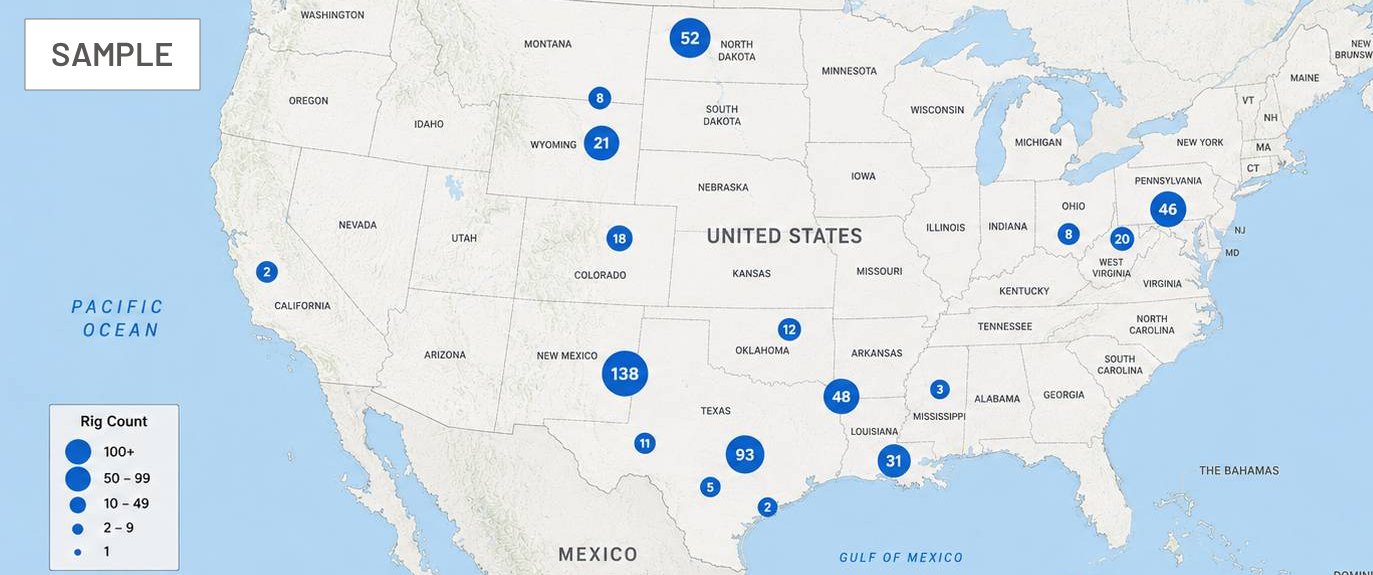
Rigs/Frac Crews by State

Loading chart data...

Rigs/Frac Crews by County

Loading chart data...

Rextag Rig & Frac Crew Activity Tracker: Our Methodology

Our methodology combines satellite intelligence, AI detection, and expert validation to deliver the most complete view of field activity available.

Traditional Surveys

  • Operator reporting

    Field rep network / surveys

  • Coverage

    Enrolled contacts only

  • Weekly updates

    Once per week

  • Known limitation

    Undercounting activity

GPS Tracking Providers

  • Hardware enrollment

    GPS-equipped rigs only

  • Coverage

    GPS-equipped rigs only

  • Daily updates

    Near real-time visibility

  • Known limitation

    Not all rigs are tracked

Rextag Methodology

  • Independent satellite observation

    All well pads, all operators

  • Coverage

    All well pads, all operators

  • Weekly validated intelligence

    Human-reviewed before publication

  • Known limitation

    Rig vs Frac not distinguished

Why Rextag?

Feature Traditional Data Rextag
Survey-based Relies on surveys and self-reported data
GPS dependent Requires hardware enrollment
Human reviewed Expert validation before publication
Captures drilling Detects active rig and frac activity Limited
Missed activity Risk of undercounting field operations Higher Lower

See the Activity Before the Market Does.

Delivered natively alongside your upstream dataset within the Energy DataLink platform

UNLOCK YOUR RIG/FRAC CREWS LAYER TODAY

Rextag Rig & Frac Crew Activity Tracker: Our Methodology

How We Count — and Why It Matters

Accurate rig and frac crew activity data requires a rigorous, transparent methodology. Understanding how activity is detected and validated is essential for making informed decisions.

The Traditional Baker Hughes Survey Approach

The Baker Hughes rig count has long been the industry benchmark, relying on operator surveys and self-reported data. While widely cited, this approach depends on voluntary participation and periodic reporting cycles.

Survey-based methods can miss activity from operators who do not participate, and updates typically lag real-world field operations by days or weeks.

The GPS Tracking Approach

GPS tracking providers offer near real-time visibility for rigs equipped with tracking hardware. This approach provides granular location data but is limited to enrolled operators and GPS-equipped equipment.

Not all rigs carry GPS devices, and coverage gaps exist across operators and basins who have not enrolled in tracking programs.

The Rextag Approach: SAR Satellite Imagery + AI Detection & Human Validation

Rextag combines Synthetic Aperture Radar (SAR) satellite imagery with AI-driven electromagnetic signature detection to identify rig and frac crew activity across all well pads and operators in the continental United States.

Our AI algorithms screen satellite data every 72 hours, scoring each detection for confidence. Human experts then verify high-confidence signals before publication, ensuring enterprise-grade accuracy.

This independent observation model does not require operator enrollment, hardware installation, or survey participation. Every well pad is monitored regardless of operator size or reporting practices.

Weekly validated intelligence is delivered natively within the Energy DataLink platform, providing both active and historical views of field activity.

A Note on Transparency

We believe in full transparency about our methodology and its known limitations. While our SAR + AI approach provides comprehensive coverage, we currently do not distinguish between rig and frac crew activity in every detection.

Our human verification process is designed to minimize false positives while maintaining broad coverage. We continuously refine our algorithms as new satellite data becomes available.

For questions about our methodology or to schedule a custom walkthrough, contact our team.